

Bangalore Blog 5 - The geography of water supply and ubiquity of water tankers

Earlier last year, my wife and I were hunting for a flat across various parts of Bangalore. One of my biggest criteria was that the apartment society would need to have a connection with water that comes from the Cauvery river and therefore not be dependent on borewells alone or worse - water tankers. In fact, I came across a brand-new property in Brookefield that didn’t even have a borewell facility (let alone Cauvery water) and survived solely on water tankers.
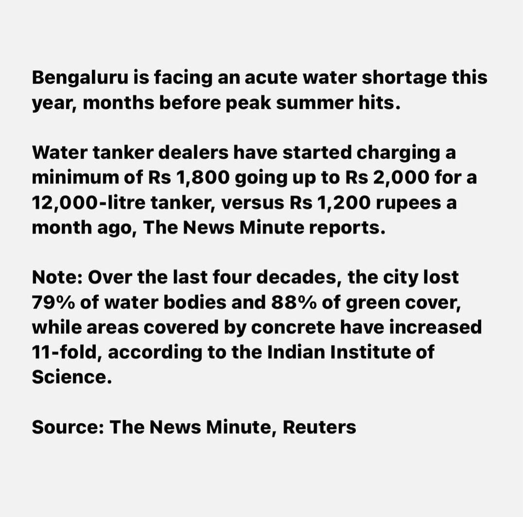
Fast forward a few months later, both - the society that I currently live in and the one we are moving into are both sending SoS alerts to it’s residents to save up on water usage as there is no water coming from the Cauvery pipeline and that water tankers were asking for exorbitant money for the supply.

If you are remotely associated with Bangalore city, you will notice that the city has notorious water tankers on the roads more than ever before.
Pardon my self-important tone but this is not something that has surprised me one bit - I saw this coming for many years now and was one of my biggest fears about the city (far more than the traffic or other issues). Why do I say so? Allow me to show the geography geek side of me and explain to you some facts.
The Geography of Bangalore -
For regular readers of this blog, you will know about my fascination with my favourite subject that is geography and I’ve cited this many times across many blogs. I follow this chap called Raj Bhagat on Twitter who beautifully puts down the issues with various cities, especially Bangalore and how it’s geography is so critical to it.
I was lucky enough to attend one of this talks last weekend where he explained so much about the geography of Bangalore and how it affects our daily lives in so many unseen ways.
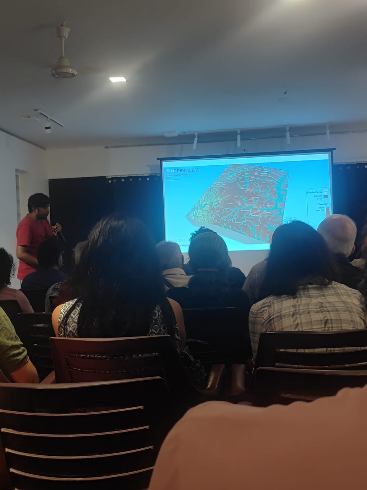
Here are the key points to understand (credit for most of these maps go to this gentleman of course):
As seen in the map below, Bangalore is located on top of a plateau where you see the black lines for the demarcation that indicated the official city boundary. It has a ridge running through the middle with the left side of the divide being the Cauvery basin side and the right side being the Ponnaiyar river side. Officially speaking, only the left side of the city is supposed to receive water from the Cauvery river but the city is growing more towards the north and east and hence needs more water there - this is one of the key points of disputes with Tamil Nadu over the usage of water from the Cauvery river. That is also one of the key reasons why a lot of eastern Bangalore does not have supply of water from the Cauvery river.
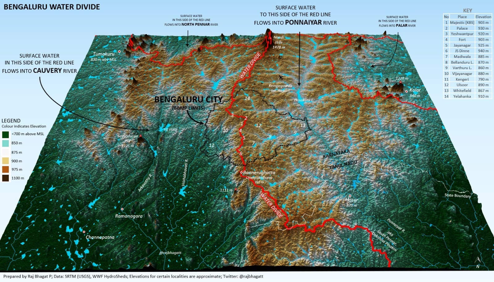
The Cauvery river is actually located at a lower altitude (of <700m) as compared to Bangalore (over 900m) and hence the water needs to be pumped UP towards the city - not an easy task at all
Bangalore is supposed to be a city of ups and downs (clearly visible if you notice how many slopes the city roads have) and this is because it has valleys across the city as seen below with the big brown patch in between being the centre of the city. Water is supposed to be drained out through these network of valleys. However, there are two waves of “development” that distorted this continuous network -

The first wave was where “bunds” were created in between these natural drainage lines which created a network of lakes instead that served the irrigation needs of the farmers earlier on. There were still enough routes and narrow lines for the water to flow downstream.

The second wave which is definitely more notorious is that there was mass construction done right on top of these drainage networks or Rajakaluves as seen below. This image is from 2015 - imagine how much worse it is now. Now the remaining routes were also largely built over.
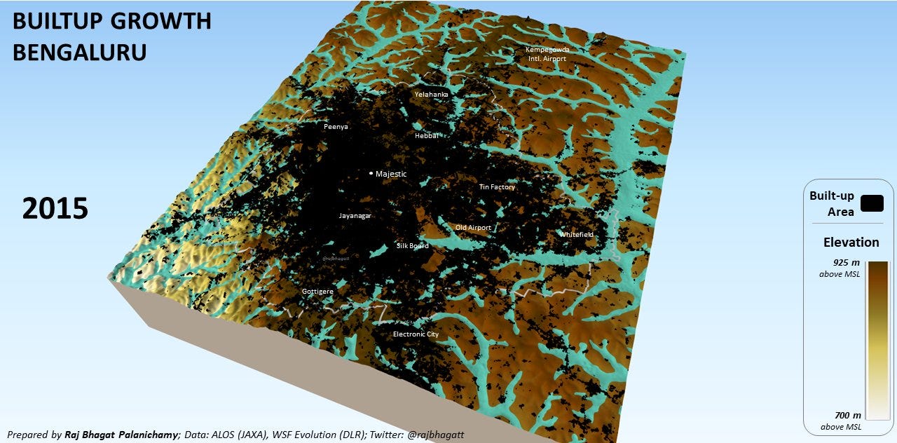
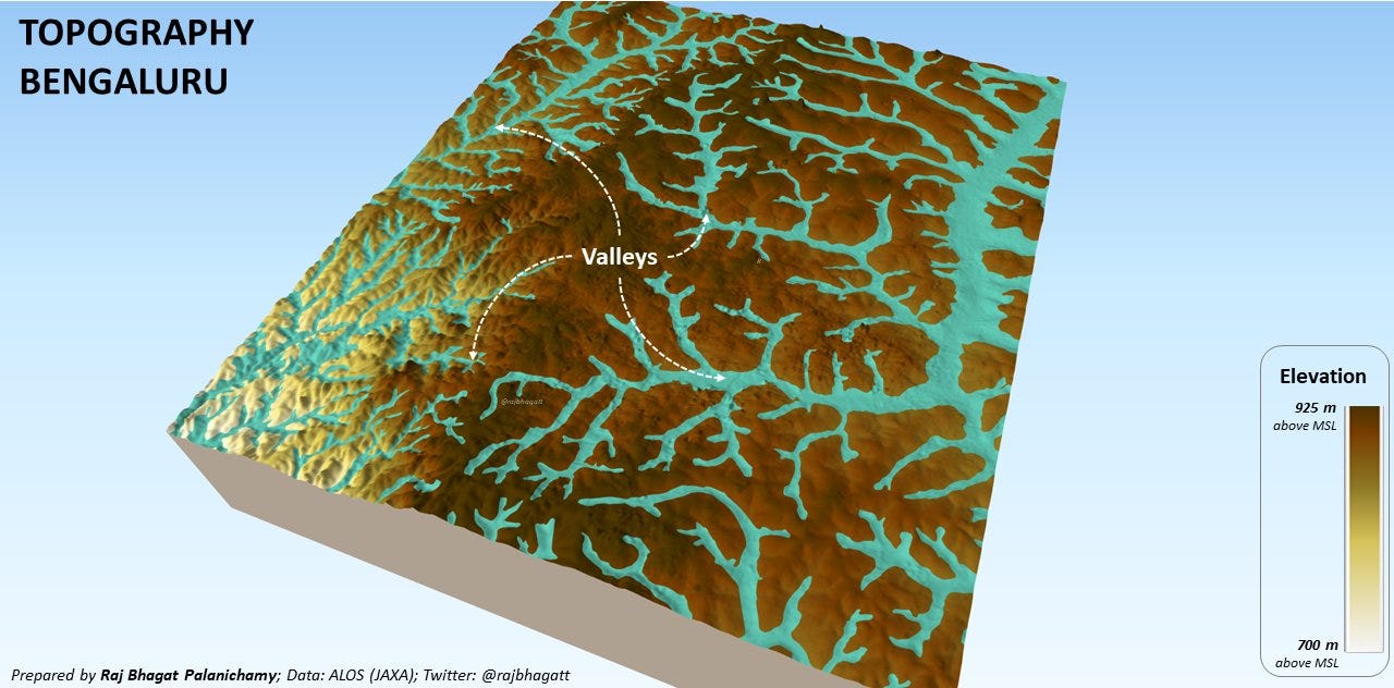


The net effect was that the city is now far more prone to flooding than ever before and many of it’s lakes are also getting killed in the process thereby removing even more sources of natural water storage that can be potentially used.
The next aspect is how there is an explosion of borewells and pumps not justt in the city but outside the city as well. We all know that the groundwater levels are depleting due to more borewells being dug everywhere.

However, one underrated aspect is that even in the rural areas around the city, there is a huge demand for underground water and lake water for irrigation purposes in order to grow all the food plants that the city demands - this too is draining water around the city
The city also has a ton of industries - that is an extremely underreported fact and factories, the construction activity and IT complexes (filled with bonsai imported from Japan) all need a lot of water.
The net effect of all this could be seen coming for many years for those who chose not to be ignorant or those who didn’t want to think of this as their problem.
On a related note, a myth I’d like to put to rest is that Bangalore does not receive as much of rainfall that it once used to - a oft mentioned point when people try to make sense of the increase in the avg temperature in the city over the last few decades. The chart below clearly shows that the average rainfall has actually increased over the last century or so.

The reason for the higher temperatures of the city is probably more to do with the concretisation everywhere and the vanishing lakes and tanks rather than the “lack of rainfall”. Yes 2023 was drier than expected but nostalgia can be based on wishful thoughts rather than facts.
The ubiquity of water tankers in the city:
I absolutely hate the sight of water tankers and it’s not hard to see why. They are all owned by mafia and goons (and I’d bet my life’s savings that they are all politically connected or owned). They are THE most notorious drivers in the city by a margin. They reflect the dystopian planning done by the city administrators. Their source of water is also not some mystical magic tap but the very groundwater that we depend on.

I know that I am supposed to end on a positive tone or give you an element of hope but I don’t know how I can do that this time. People find some weird sense of pride in the rapid “growth” of their city. On the contrary, I hope that Bangalore does not grow anymore - at least not the way it is growing now. All those MNCs can all flock to Hyderabad and Gurugram or wherever. This city simply cannot sustain this rate of development anymore. Greedy builders like Prestige are building even more “tech parks” on top of sensitive land - be it near Bellandur Lake or Varthur Lake. Sobha is building apartments right on top of natural drainage lines near Varthur. I have ranted enough on this topic in my previous blogs.
There are some attempts to diversify water supply from the Sharavati reservoir 300 km away. I do not know how feasible or environmentally sustainable idea this is.

I think that the availability of water is the most under-the-rader crisis that has been coming for many years now not just in Bangalore but all across India. Mumbai, Chennai and many other cities face serious issues with water in the future. And no - building more dams is not the solution to everything - most of the water is anyway used for criminal deeds like growing Basmati rice in temperate regions like Punjab and then demand a MSP for it.

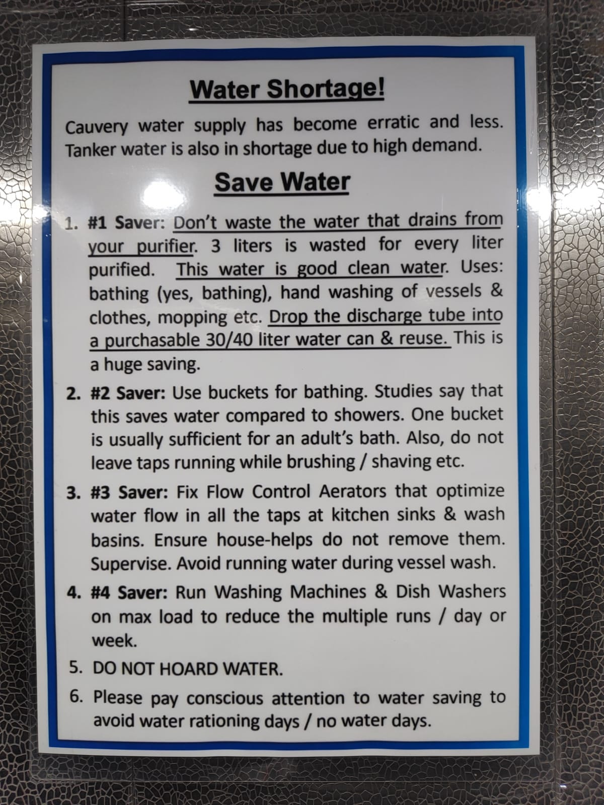
I’ll close this piece with this photo I took in the apartment lift 2 hours ago.
Very well researched and so informative! Thanks!
Bro, how do we so something about this